St. François County, Missouri · T35N R4E · The Southeast Missouri Iron District
Iron Mountain
One mountain, worked for more than two centuries — from a Spanish grant, through furnaces and war, to shafts a thousand feet down, and a quarry still running today.
Every entry below is tagged with its source and its verification status.
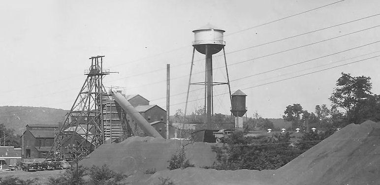
Plate I · The surface plant in the Ozark Ore years — headframe, mill & water tower · real-photo postcard, date under research
Iron Mountain was not, as promotional literature once claimed, a solid mass of ore. It was a real, extensively documented mine. This site draws on military records, period newspapers, state mine maps, and physical evidence on the ground.
Claims not yet traced to a primary source are marked as open questions, not presented as fact.
The Timeline
Six eras · sources cited · in progress
Era I
Origins & Grant · 1797–1836
The mountain changes hands before anyone digs.
1797
The Spanish grant
A Spanish colonial land grant records the tract. Local tradition holds it was given to Joseph Pratte, a regional peacemaker, in thanks for his services — and that he asked for the mountain itself.
Tradition · Grant documented; Pratte story per local histories
1833
Title finally confirmed
The Missouri Board of Land Commissioners formally confirms the claim to Pratte's heirs — decades after his death. Spanish-era titles took that long to untangle after the Louisiana Purchase.
Documented · Land Commissioners records, via published histories
Era II
Industrial Founding · 1836–1861
Companies form, fail, and finally take hold. The furnaces light.
1836
The Missouri Iron Company — and its failure
The first company organized to work the mountain forms in 1836. It fails, and the property is sold at sheriff's sale.
Documented · Published county & district histories
1843/1845–1893
The American Iron Mountain Company
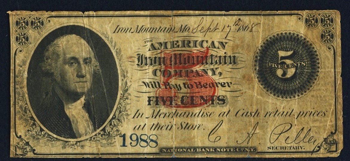
Published local histories and period newspaper accounts date the American Iron Mountain Company's takeover of the property to 1843. The company's own shipping records, held at the State Historical Society of Missouri, instead date the acquisition to 1845 and name James Harrison of Chouteau, Harrison and Valle (St. Louis) as head of the firm; neither source names a "Conrad Zeigler" cited in some published histories. This date and leadership discrepancy is unresolved. The company sinks the first pits and shafts in 1844 — the likely origin of the Big Cut — and builds furnaces in 1846 and 1850, adding hot blast stacks in 1854, the first west of the Mississippi River. Pig iron was hauled by wagon to Sainte Genevieve for shipment by steamboat and barge, principally to Chouteau, Harrison and Valle, with additional shipments to Pittsburgh and Louisville. The Iron Mountain, Pilot Knob, and Sainte Genevieve Plank Road, easing this haul, was built in 1858. A mid-1800s newspaper account puts employment at roughly 300 hands running three furnaces; the company controlled some 32,000 acres, much of it timber land to feed the charcoal supply, so a large share of those 300 worked in the woods and at the furnaces, not in the pits. Company shipping records place its operation of the property through 1893.
Restricted competition within the company concession
Only company-owned stores were permitted to operate within the Iron Mountain company's land concession. Individuals seeking to open competing stores were required to build outside the concession boundary. This restriction produced a separate settlement between Iron Mountain and Doe Run, originally called Fairview, later nicknamed "Hog Eye," documented in the Handbook of Missouri (1881), and renamed Haggai in 1890. A comparable arrangement is documented at Middlebrook, Iron County. The 1881 date places this within the American Iron Mountain Company's operation of the property (1843–1909).
Verified · Zimmer (1944); corroborated by Ramsay, Our Storehouse of Missouri Place Names (1952)
Era III
The War Years · 1861–1865
The mountain becomes strategic ground.
1861–1865
Federal occupation of the district
Union forces held the Iron Mountain district through the Civil War. The district's iron was strategically significant to the Union war effort, including the construction of ironclad gunboats — placing this remote Missouri property in the supply chain of the river war.
The 25th Missouri Infantry moved to Iron Mountain in March 1863, part of the federal garrison protecting the district and its rail connection during the middle years of the war.
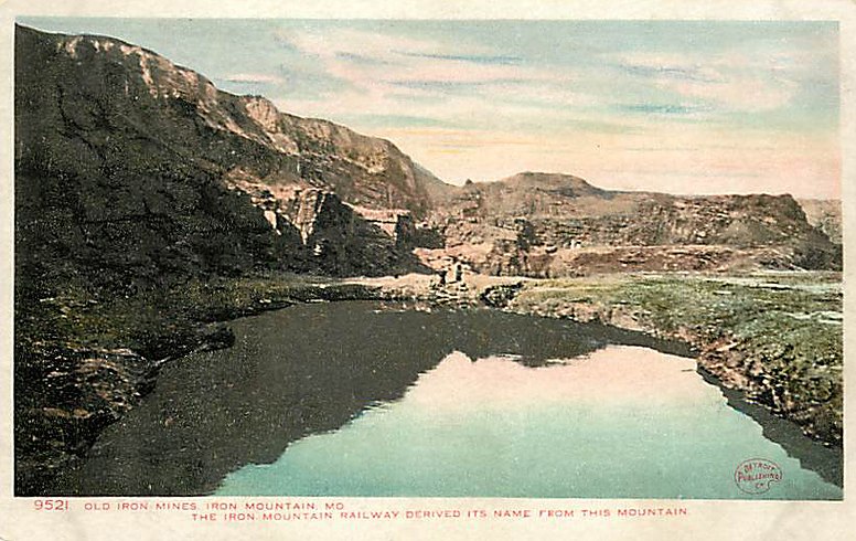
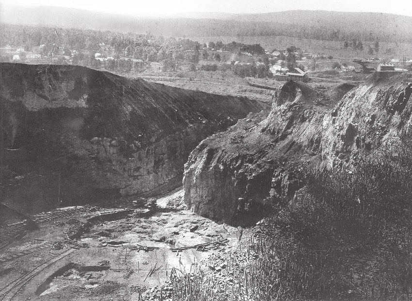
The main open-pit working stood abandoned and was photographed in this condition in the early 1900s — the image survives in the Missouri Geological Survey Photo Archives (see Plate VI below).
During the idle years, a race track operated immediately west of the Missouri-Pacific railroad right of way — a reminder that the property's life between mining eras wasn't empty, just different.
Documented · Local histories; mapping research ongoing
Era V
The Revival · 1920–1966
New money, deeper shafts, harder rock — the modern mine.
May 1920
Busby buys the mountain
Leonard A. Busby of Chicago — president of the Chicago Surface Lines — buys the property and organizes a new Iron Mountain Company. Between 1920 and 1927, he and his associates spend over one million dollars trying to revive mining, roughly three-quarters of it Busby's own money.
His operation marks a real turning point: the first underground mining to reach ore hosted in the crystalline igneous rock itself. Earlier underground work had chased the shallower conglomerate ore just beneath the sedimentary cap — technically underground, but nothing like this depth or hardness.
Documented · Judge Edgar's local histories, ca. 1940s
Sept. 18, 1923
Fire destroys the original wooden hoist works
About one o'clock in the morning, a gasoline torch exploded in the hoist house of the Iron Mountain Mining Company — electric lights had not yet been installed there. Hoist engineer Joe Oatman, on shift, narrowly escaped as flames filled the room. The wooden hoist house and its timber hoisting tower — the predecessors of the brick hoist house and steel headframe that stand today — burned to the ground, and blazing timbers fell into the shaft. Twenty men working underground escaped through a tunnel completed only days earlier.
Busby interests the M. A. Hanna Company of Cleveland, whose funds finance new exploration — and new ore bodies are discovered that had escaped every previous owner.
Documented · Judge Edgar's local histories, ca. 1940s
1930s–1966
The Hanna / Ozark Ore era
Hanna-era operations — under the Ozark Ore Company and later Midwest Ore Company names — work the deposit underground for three decades. The surviving surface plant dates largely to this era, including the hoist house standing today (estimated built around 1951 — confirmation pending) and the surface plant documented in detail on the 1961 company maps.
The rock itself becomes the product — beginning while the ore was still coming up.
by February 1962 – 1977
The first quarrymen — the Elders
A letterhead dated February 28, 1962 proves the quarry running years before the mine closed: the Trap Rock Material & Engineering Co., trading as Iron Mountain Trap Rock — Gretchen K. Elder, president; Chas. B. Elder Jr., vice-president — washing and grading aggregate to specification while Hanna was still hoisting ore. Family account credits Chuck Elder, a mining engineer of the Hanna years, with the property's first quarry blast and with the idea itself: the mountain's rock as the product. He died with the operation still young. The Elders' full story is an open research thread — see the ledger.
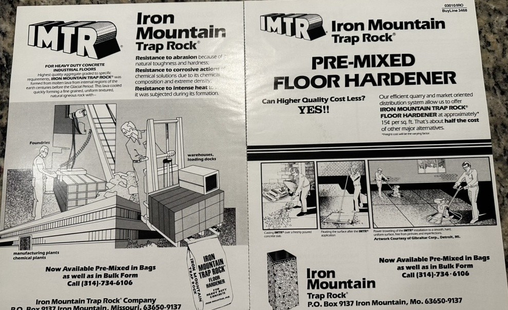
In 1977, John and Marge Malloy buy the property and accomplish what no one had since the ore gave out: they make the quarry idea work — and last. Elder had proven the concept and died with it young; the Malloys build the business. They reopen the rock, run the washplant, and build IMTR — Iron Mountain Trap Rock — into a branded pre-mixed floor hardener sold in bags and bulk to foundries, warehouses, and manufacturing and chemical plants, prized for its abrasion resistance and heat resistance as a natural igneous aggregate. (Railroad ballast came later, under Fred Weber; it was not a Malloy-era product.) They raise their family on the mine property itself, living where a century of operators had only worked. Barely a year in, the 1978 mill fire tests the young operation; it survives and keeps growing. Over twenty years the Malloys turn Iron Mountain Trap Rock from a name on a letterhead into an institution — the identity of the mountain itself — and when they sell in 1997, the quarry is strong enough that every owner since has simply carried their operation forward. The modern working life of Iron Mountain is the Malloys' doing.
Verified · Family record — firsthand account; IMTR floor hardener product line confirmed by period sales flyer (Plate IX)
1978
Fire destroys the mill
Fire strikes the property a second time, fifty-five years after the wooden hoist works burned. This time it takes the mill — completely destroyed. The headframe standing beside it survives, and stands still. The fire came just a year into the Malloy ownership, witnessed firsthand.
Verified · Family record — firsthand account · press confirmation pending
1997–2021
Fred Weber, Inc.
The Malloys sell to Fred Weber, Inc. of Maryland Heights, Missouri, which keeps the Iron Mountain Trap Rock Company name and operates it as a subsidiary for the next quarter century — sustaining Iron Mountain's claim as one of the longest continuously worked mine properties in the United States. Railroad ballast — the coarse, heat- and abrasion-resistant crushed stone laid under rail track — becomes part of the product line under Weber, alongside road stone and construction aggregate; it was not a Malloy-era product.
Verified · Family record; company records · railroad ballast product line under Fred Weber, corroboration in progress
2021–present
New Frontier Materials
On July 15, 2021, Fred Weber sells its aggregates and asphalt assets — the Iron Mountain quarry among them — to New Frontier Materials, a St. Louis construction materials platform formed in 2020. The quarry operations become the core of the new company; Fred Weber itself continues separately in concrete products and contracting. With the sale, the Iron Mountain Trap Rock name — in use since at least February 1962 — is retired after nearly six decades on the mountain; the quarry operates under the NFM banner thereafter.
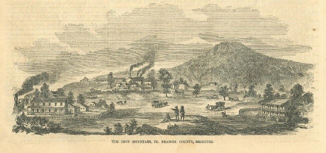
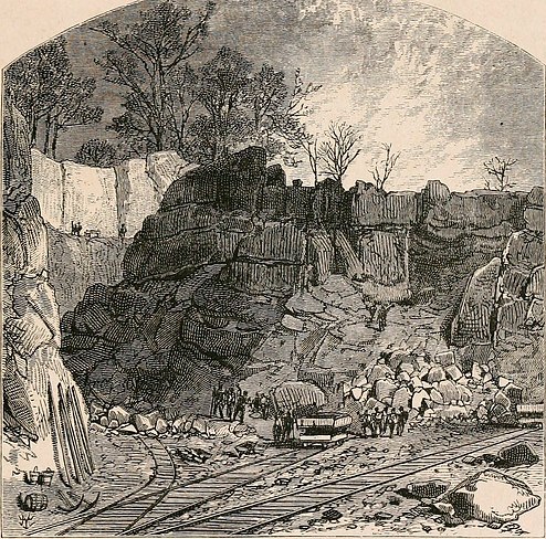
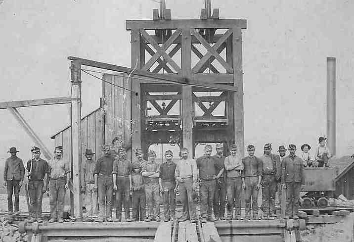
Period images of the workings · dates & sources under research where noted
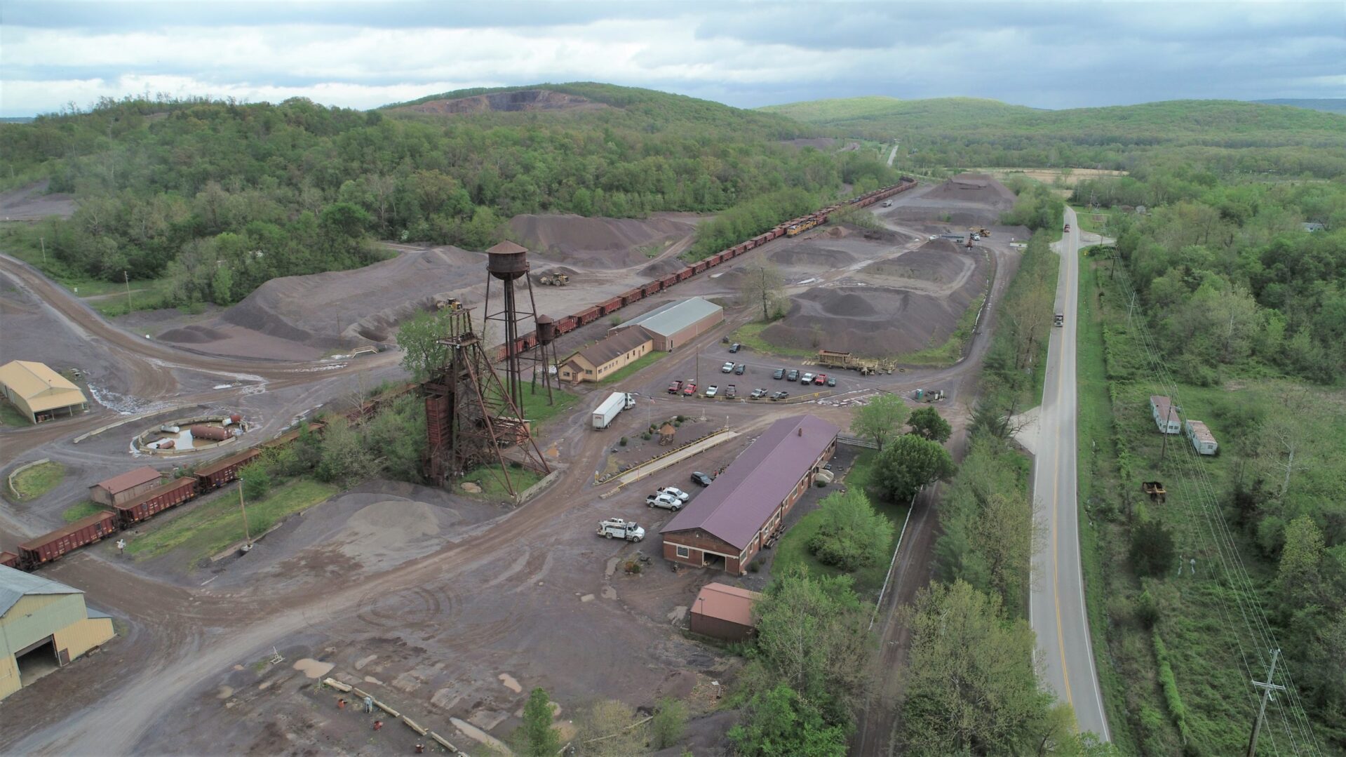
Plate II · "The Iron Mountain, St. Francis County, Missouri" — Ballou's Pictorial, 1857 · the mountain still whole, the furnace town at its feetPlate III · The open cut in the furnace era — period wood engraving, publication under researchPlate IV · A mine crew at a timber headframe — photograph, date under researchPlate V · "Old Iron Mines" — Detroit Publishing postcard No. 9521, early 1900s; the flooded workings of the idle yearsPlate VI · The Big Cut, abandoned — early 1900s · Missouri Geological Survey Photo ArchivesPlate VII · The property from the air, April 29, 2020 — headframe & water tower at center; ore cars on the internal rail line; trap rock stockpiled beyond; Highway N at right; the mountain behind · Photograph: Fred Weber, Inc. / Iron Mountain Trap Rock Co.Plate VIII · The town's own money — American Iron Mountain Company 5¢ scrip, Sept. 17, 1868. "Will Pay to Bearer FIVE CENTS In Merchandise at Cash retail prices at their Store." Serial 1988, signed by the company secretary; engraved by the National Bank Note Co., N.Y., in imitation of federal fractional currency. Located July 2026, answering the question Eric P. Newman posed to Charles B. Elder Jr. in 1962 · Image: Heritage Auctions, HA.com (Sale 3567, Lot 22214)Plate IX · Iron Mountain Trap Rock Co. sales flyer for IMTR pre-mixed floor hardener — the Malloy-era product line, sold pre-mixed in bags and bulk for foundries, warehouses, and manufacturing/chemical plants; P.O. Box 9137, Iron Mountain, Mo. 63650-9137 · Image: family record
The Landscape That Remains
Structures & features on the property
Standing
The Hoist House
The building that housed the hoisting works — estimated built around 1951, well after the 1923 fire destroyed its predecessor. Later repurposed as a residence, it remains the anchor of the property's industrial footprint.
Standing
The Headframe
The structure that stood over the shaft, carrying cables between the hoist and the workings below. Its alignment with the hoist house still reads clearly on the ground.
Identified
The Thickener
An octagonal, rock-filled structure behind the hoist house — long unidentified, now confirmed as a thickener: a clarifying tank with slow-rotating rake arms, part of the mine-water circuit. Its label appears on Map 00636, "Surface Map Showing Plant Site," Dec. 7, 1961 (Midwest Ore Co. / M. A. Hanna Co.). Its position behind the hoist house, not the mill, points to a shaft-water dewatering role.
Documented
The Big Cut
The main surface open-pit working of the mountain itself — likely begun with the first pits of 1844, photographed abandoned in the early 1900s, and named on the 1961 surface map.
Documented
Hayes Cut & Newman Cut
Two more named cuts on the property, both appearing on the 1961 Murphy & Mejia surface map. "Hayes Cut" was in print by October 1961 in a Missouri Geological Survey guidebook edited by William Clifton Hayes Jr., the state geologist — a leading candidate for the namesake. Newman's namesake is still unknown.
Vanished
The Mill
The ore-processing mill stood near the headframe until 1978, when fire destroyed it completely — the property's second great fire. The headframe beside it survived. The mill's footprint and any surviving foundations are candidates for documentation.
Vanished
The Little Mountain
A smaller summit west of the main mountain — mined away entirely. Per Judge Edgar, "the little mountain became a great hole in the ground": an open cut following a vein dipping 38°, worked to 280 feet, with a shaft then sunk at its base — the earliest documented shaft on the property.
Traces
The Water System
A stone dam on Indian Creek formed a lake up the valley; water was pumped to a 700,000-gallon concrete tank on a neighboring summit and piped down at 25–40 psi to hydraulic the ore piles. What survives of this system is under investigation.
Open Questions
The research ledger · what we're still chasing
1962–1977
The Elder years — now anchored at the start by the February 1962 Iron Mountain Trap Rock letterhead (Gretchen K. Elder, president; Chas. B. Elder Jr., vice-president). Still open: who Gretchen was, whether Charles B. Elder Sr. or Jr. was the Hanna engineer, and how the company or its name passed to the Malloys in 1977.
Hoist house
Exact construction year and builder of the surviving hoist house. Current estimate is circa 1951; confirmation pending from builder records.
Namesakes
Who were Hayes and Newman? The Hayes Cut has a strong candidate in state geologist William Clifton Hayes Jr.; Newman remains a blank.
The garrison
Where exactly on the property did the Civil War garrison sit? The Official Records (Series I, Vols. 3 and 41) and the Missouri Union Provost Marshal Papers remain to be searched.
Known errors
Two conflations appear in secondary and AI-generated sources and are flagged here so others don't repeat them: "Camp Iron Mountain" refers to a WWII-era facility in California, not this property; and the Missouri Mines State Historic Site in Park Hills is an unrelated lead-mining site.
Get in touch
Have a correction, a source, a photo, or a lead on any of the open questions above? Send it here.